Overview
Black Peak (Kalanag) — The Highest Summit of the Saraswati Group
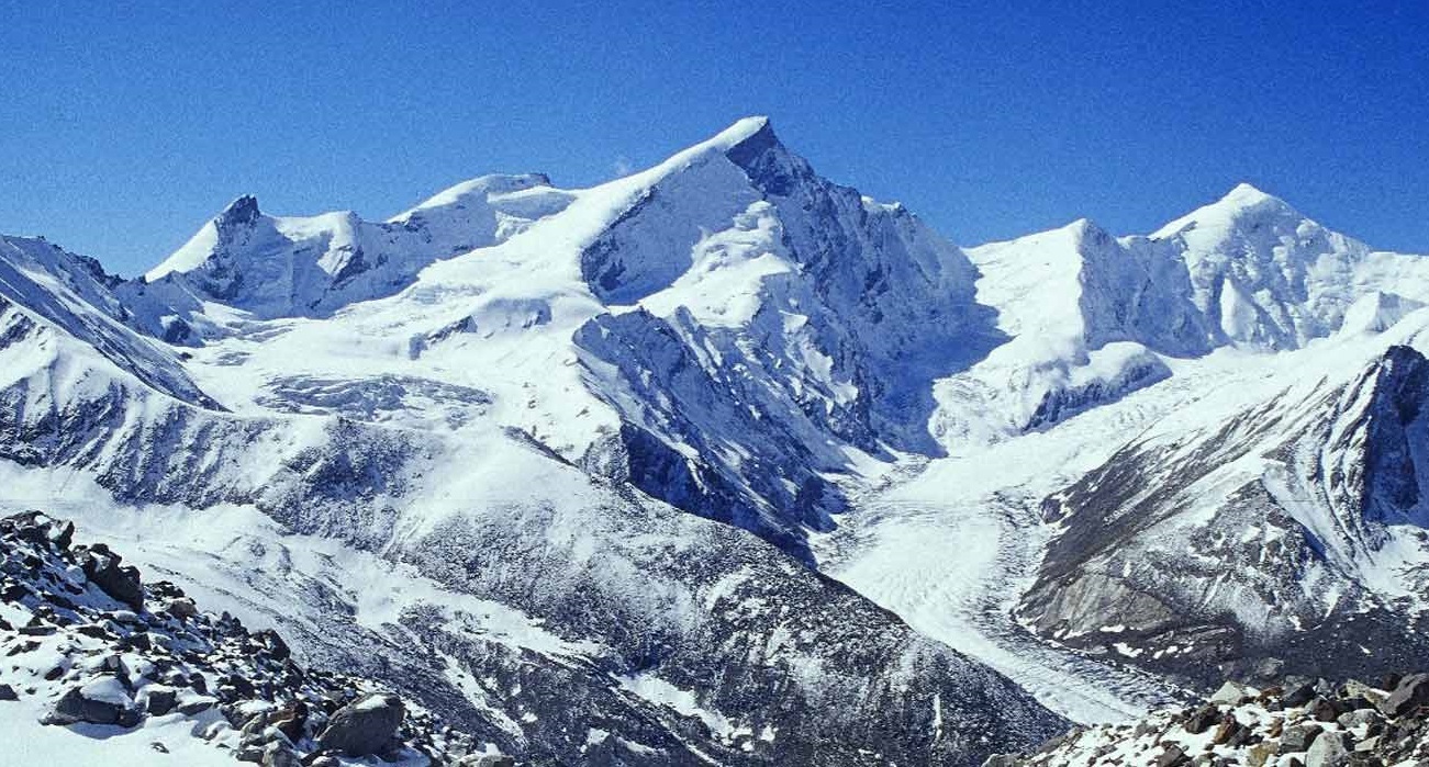
Black Peak — known locally as Kalanag (literally "black serpent") for the dark serpentine granite of its summit ridge — is the highest peak of the Saraswati group at 20,725 ft (6,317 m) and one of the most coveted Grade-II expedition objectives in Garhwal. The eleven-day climb begins at Sankri in the upper Tons valley, follows the classic Bali Pass approach to Ruinsara Tal, then ascends a new line up the Saraswati glacier to high camps and a technical summit push that combines fixed-line snow climbs, an ice-wall pitch, and an exposed final ridge. It is not a trek — it is a working alpine expedition that demands prior mountaineering certification, glacier experience, and full technical gear.
Why Kalanag matters
Black Peak occupies a specific place in Indian mountaineering lore. The peak was first climbed in 1955 by an Indian Army team led by Major N. Kumar as part of the early post-independence push to establish Indian mountaineering on classic objectives previously dominated by British and European expeditions. Since then it has become the standard graduation peak for trekkers stepping up from non-technical 6,000 m peaks (Stok Kangri, Friendship Peak) into proper Grade-II climbs. The summit panorama is one of the great views in Garhwal: the Bandarpoonch wall directly across the valley, the Swargarohini massif (the Pandavas' ascent route in the Mahabharata) due east, and the entire Gangotri group on the eastern horizon.
The geography of the Saraswati group
The Saraswati group is a sub-range of the Bandarpoonch massif, named for the Saraswati glacier that drains its southern flank into the Ruinsara Nala. The group includes Kalanag (20,725 ft), Bandarpoonch I (20,722 ft), Bandarpoonch II (20,407 ft), and several unnamed satellite peaks. The Saraswati glacier descends from the col between Kalanag and Bandarpoonch to about 14,000 ft and is the key access feature for any climb in the group. Ruinsara Tal at 11,800 ft is the standard basecamp and acclimatisation lake for both Kalanag and Bandarpoonch expeditions.
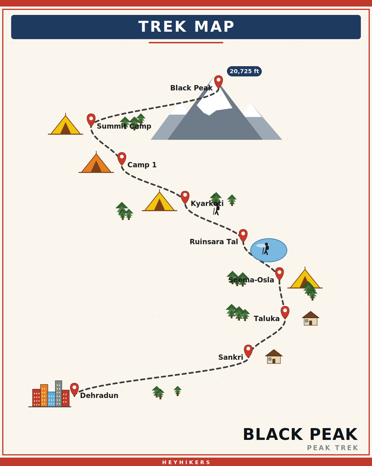
The route from Sankri
The expedition begins at Sankri (6,400 ft), the standard upper-Tons trailhead. Day 2 covers the well-known approach via Taluka and Seema-Osla. Day 3 moves up the Ruinsara Nala to Ruinsara Tal (11,800 ft), the basecamp. Day 4 is acclimatisation and gear drills. Day 5 establishes Advanced Base Camp at Kyarkoti (13,500 ft). Day 6 moves onto the Saraswati glacier to Camp 1 at 16,500 ft. Day 7 is a short technical move up a fixed-rope snow slope to the Summit Camp (Camp 2) at 19,000 ft. Day 8 is summit day. Days 9-11 retrace the descent and drive out.
The summit day in detail
Wake at 1 AM. On the trail by 2:30 AM with crampons and harness. The first two hours is a snow climb across the upper shoulder, roped in two-person teams. The route then arrives at the base of the summit ridge — a 400 m mixed snow-and-ice climb at 45-55° where we deploy fixed ropes and ascend with jumars. The middle section has a 50 m near-vertical ice wall that requires two ice tools and front-pointing; the lead guides fix two ropes and belay each climber up. Above the ice wall the ridge eases into a final 100 m snow slope to the summit. Most groups summit by 8-9 AM. Stay no more than 20 minutes (typically -20°C with wind), descend the same fixed lines with rappel-and-belay back to Camp 1.
Difficulty and prerequisites
Kalanag is a Grade-II IMF expedition peak. We require a Basic or Advanced Mountaineering Course certificate from NIM (Uttarkashi), HMI (Darjeeling), JIM (Pahalgam), or equivalent; references from at least two prior 6,000 m+ expeditions; demonstrated proficiency in fixed-line ascent with jumar, ice-axe self-arrest, crampon technique, and crevasse-rescue procedures; cardiovascular fitness equivalent to running 10 km in 50 minutes; and a current medical fitness certificate including ECG and a chest X-ray. We also require IMF / state mountaineering federation registration which we facilitate as part of the package.
Permits and registration
Black Peak requires three layers of permits: Indian Mountaineering Foundation (IMF) Peak Booking — applied for 90 days in advance, with a per-team fee and per-climber fee; Forest Department permits for entry into Govind Pashu Vihar Wildlife Sanctuary; and local guide registration through the Uttarkashi sub-divisional magistrate's office. Foreign nationals require additional inner-line area permits. We handle all paperwork; trekkers must submit passport copies and medical certificates 60 days in advance.
Best season
Kalanag has two narrow windows. Mid-May to mid-June (pre-monsoon) is the more reliable window — consolidated snow on the upper face, predictable weather, and less rockfall on the moraine. Mid-September to mid-October (post-monsoon) is the second window — clearer air, drier snow, and excellent visibility, but with shorter daylight and colder summit-camp nights. Outside these windows the route is either monsoon-soaked (July-August), heavily snow-loaded with avalanche risk (November onwards), or buried in deep winter snow (December-April). Pre-monsoon batches have approximately 70% summit success rate; post-monsoon about 60%.
Camping and infrastructure
The expedition uses six camps: Sankri guesthouse, Seema-Osla camp, Ruinsara Tal basecamp, Kyarkoti ABC, Camp 1 (16,500 ft), and Summit Camp / Camp 2 (19,000 ft). HeyHikers provides high-altitude tents (4-season, double-walled), -25°C sleeping bags, kitchen tents with full-time cooks below ABC, fixed ropes, snow bars, ice screws, anchors, and a satellite communicator. Climbers carry personal technical gear (harness, helmet, jumars, descenders, crampons, ice axe — rentals available with advance booking) and personal layered clothing. Above Camp 1 climbers carry a 10-12 kg load including their own bivvy gear.
Safety and protocol
Every Kalanag expedition has an IMF-certified expedition leader, two assistant guides, and a high-altitude porter team. We carry a portable hyperbaric chamber (Gamow bag) and oxygen cylinders to ABC. Pulse oximetry is checked daily at every camp; anyone with sustained SpO2 below 80% is descended immediately. Weather is monitored via satellite phone twice daily. The expedition leader has authority to abort the summit attempt at any point; this authority is non-negotiable.
Itinerary
Map
What trekkers say
"I'd never camped in snow before. The HeyHikers team made me feel safe every single step. The summit sunrise — standing at 12,500 ft watching peaks turn gold — I cried. Not from the cold. From the beauty."
PS
Priya Sharma
Kedarkantha, Dec 2025
"Seven lakes, each more unreal than the last. The logistics were flawless — the food at 13,000 ft was better than most restaurants I know. Our guide Farooq knew every stone on the trail. Doing Goechala with them next."
AM
Arjun Mehta
Kashmir Great Lakes, Aug 2025
Inclusion
- All meals during the trek (vegetarian, freshly cooked)
- Camping gear — tents, sleeping bags, mats
- Certified trek leader and support guides
- Forest department permits and entry fees
- First-aid kit and supplemental oxygen
- Basecamp accommodation on twin/triple sharing
Exclusion
- Travel to and from the basecamp pickup point
- Personal trekking gear and clothing
- Travel insurance covering high-altitude trekking
- Tips, personal expenses, and meals during travel days
- Anything not explicitly listed under inclusions
Things to Carry
- Trekking shoes (high-ankle, broken-in)
- 40-50L backpack with rain cover
- Two pairs of trek pants
- Three full-sleeve t-shirts (synthetic, not cotton)
- Fleece jacket and a heavier down/insulated jacket
- Thermal innerwear (top + bottom)
- Waterproof outer shell (jacket + pants)
- Woollen cap, sun cap, balaclava
- Two pairs of warm gloves (inner liner + outer)
- UV-rated sunglasses
- Headlamp with spare batteries
- Reusable water bottles (2L total) or hydration bladder
- Personal medical kit and prescription medicines
- Sunscreen (SPF 50+) and lip balm
- Toiletries and quick-dry towel
- Original photo ID (mandatory at forest checkposts)
How to Reach
Reach Dehradun. Our shared transport leaves at 6:30 AM on Day 1 and reaches Sankri in 9-10 hours.
Safety & Security
- Acclimatize properly — never skip rest days at altitude.
- Drink at least 4 litres of water per day above 9,000 ft.
- Tell your trek leader immediately if you feel headache, nausea, or breathlessness — early AMS signs are treatable, ignored ones are not.
- Stay close to the group; do not take shortcuts off the marked trail.
- Avoid alcohol and smoking for the entire duration of the trek.
- Keep a buffer day for travel — Himalayan roads can close without notice.
- Carry travel insurance that explicitly covers high-altitude trekking and helicopter evacuation.
Cancellation Policy
Cancellations must be requested in writing.
- More than 30 days before the trek start date: 90% refund. - 21–30 days before: 50% refund. - 11–20 days before: 25% refund. - 10 days or fewer: no refund, but you may transfer your slot to another trekker or to any future batch within 12 months at no extra charge.
Refunds are processed to the original payment method within 7-10 working days. Trip cancellations triggered by us (weather, force majeure, government restrictions) are refunded in full or moved to an alternate batch at your option.
Meet your trek leader
Akhil Deruwan
NIM Uttarkashi certified · 9 yrs experience
Akhil grew up in the foothills of the Garhwal Himalayas and has spent nearly a decade navigating its most demanding trails. He has led over 150 batches across Uttarakhand and Himachal Pradesh, with a strong focus on technical high-altitude routes and safety management. His calm under pressure and deep knowledge of local terrain make him a trusted leader for both beginner and advanced trekkers.
- Wilderness First Responder
- High Altitude Medicine
- Technical Route Navigation
- Search & Rescue
FAQ
Why Trek With Us
Travel Safe
Certified Team
Easy Cancellation
Well Equipped Campsite
Experienced Guide
No Hidden Charges