Overview
Deo Tibba Base Camp — Beneath the South Face of the Twin Peaks
Deo Tibba Base Camp at 14,500 ft (4,420 m) sits at the foot of one of the most photogenic mountain walls in the Indian Himalayas — the 5,000 ft south face of Mt. Deo Tibba (19,688 ft / 6,001 m) and its sharper twin Mt. Indrasan (20,410 ft / 6,221 m). Across six unhurried days the trek climbs through deodar forest, past the wildflower meadow of Seri, onto windswept moraine at Tainta, and into the alpine bowl beneath the peaks. It is the textbook moderate Himalayan trek for trekkers who want true high-altitude exposure without committing to a crossover or a technical pass.
The geography that makes it special
Deo Tibba and Indrasan are the two highest summits of the central Pir Panjal range, standing barely four kilometres apart on a single connecting ridge separated by the Duhangan Col. Together they form what locals call the twin peaks of the Kullu valley — visible from Manali, from Naggar, and on clear days from as far south as Bilaspur. The trek approaches from the south up the Jagatsukh nala, a tributary of the Beas that drains the Duhangan glacier system. The valley is U-shaped (a classic glacial trough), with a clear sequence of altitude zones: deodar-oak forest below 10,000 ft, silver birch and rhododendron between 10,000 and 11,500 ft, alpine meadow up to 12,500 ft, and moraine-and-snow above. Each zone gets its own day of the trek, which makes Deo Tibba an exceptional acclimatization profile — a textbook walk-high-sleep-low ascent.
The route from Jagatsukh
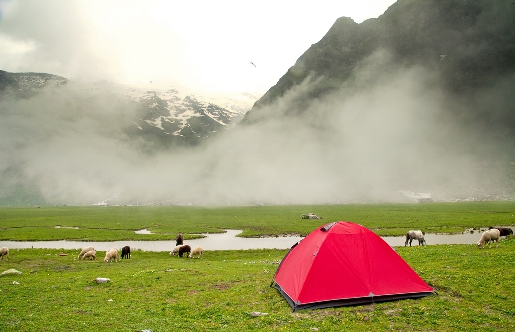
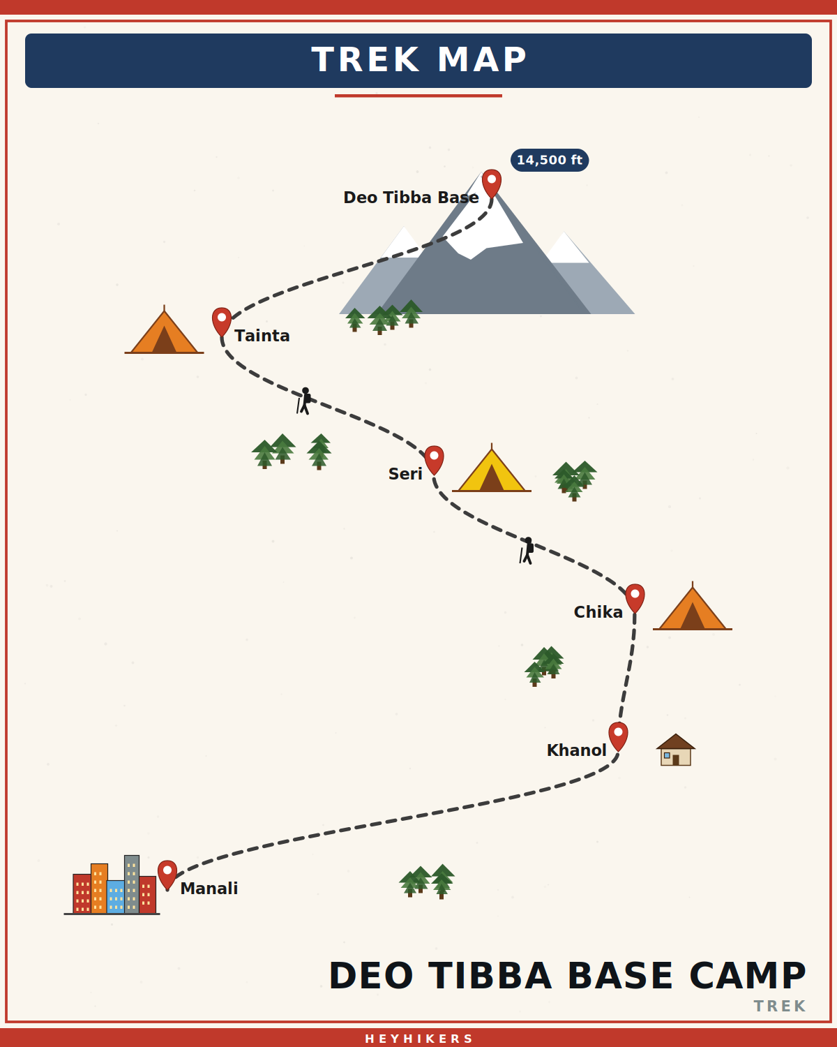
The trek begins at Jagatsukh (5,800 ft), one of the oldest villages in the Kullu valley and the seat of the original Kullu kings before they shifted to Naggar in the 8th century. The two surviving 8th-century shikhara temples here — Sandhya Devi and Gayatri — are among the finest examples of early Pratihara stone architecture in the western Himalayas. From Jagatsukh a narrow road climbs through apple orchards to Khanol (7,200 ft), the road-head where the foot trail begins. Day 1 climbs through deodar and oak to the Chika campsite at 9,500 ft. Day 2 emerges from the tree-line into the meadow of Seri (11,200 ft) — a kilometre-long alpine bowl carpeted with anemones, primulas, and Himalayan blue poppies in early summer, and one of the most photographed campsites in the Indian Himalayas. Day 3 climbs onto moraine at Tainta (12,800 ft), where a small glacial pond catches the south face of Deo Tibba in mirror reflection on calm mornings.
The base camp day
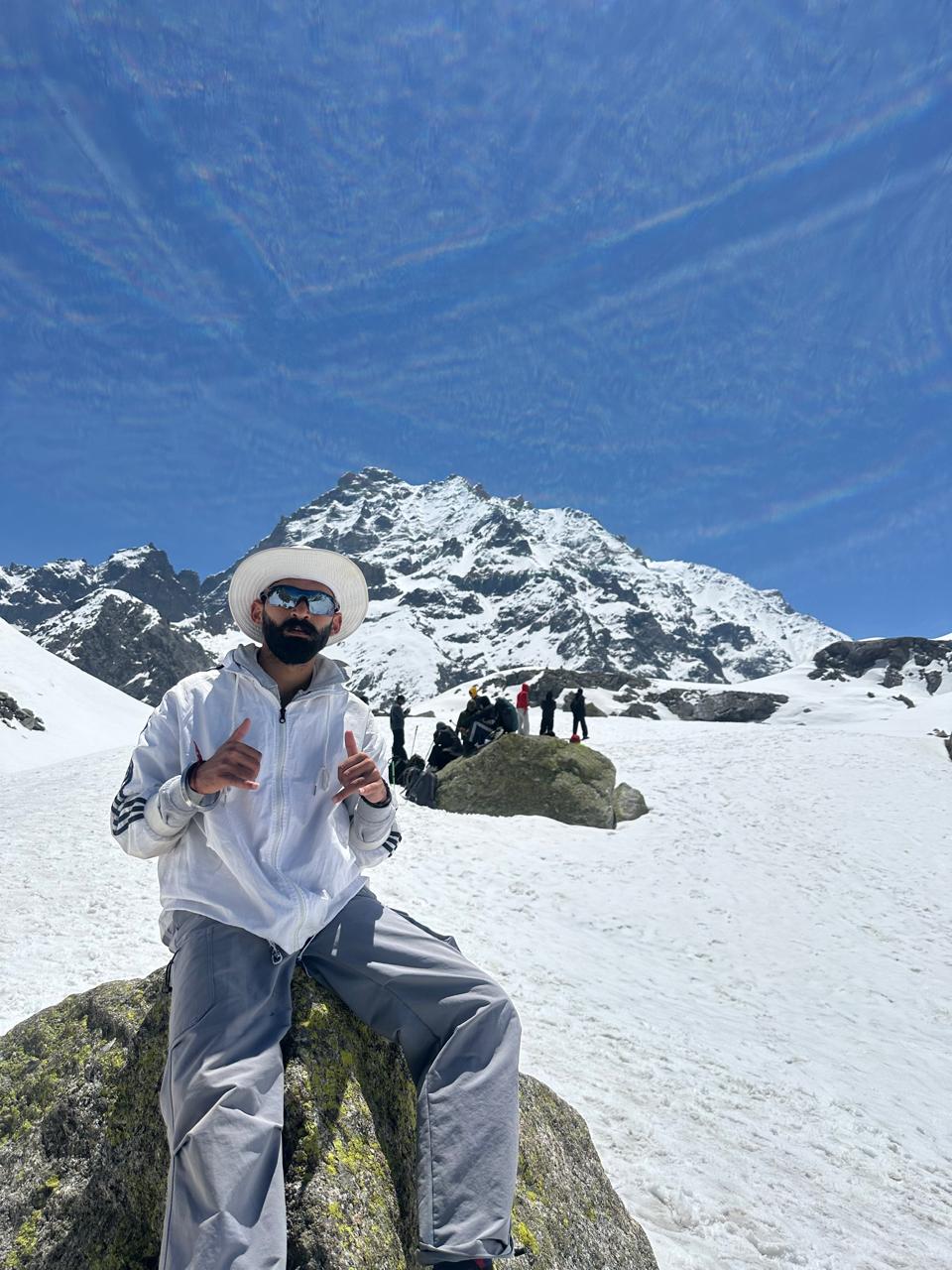
Day 4 is the trek's high point — a six-hour round-trip day-hike from Tainta to Base Camp at 14,500 ft and back. We start at 6 AM and reach the camp by 9-10 AM, in time for a thirty-minute stay before the typical afternoon weather closes in. The view from Base Camp is the centrepiece of the trek: the south face of Deo Tibba rising 5,000 ft directly above, the sharper pyramid of Indrasan to its left, the Duhangan Col and the small Duhangan glacier between them, and on exceptionally clear days the Pir Panjal range visible to the west all the way to the unnamed peaks above Bara Bhangal. This is one of the few Indian treks where you can stand at the foot of two 20,000+ ft peaks without any technical climbing.
Mountaineering history
Both Deo Tibba and Indrasan have storied first-ascent histories. Deo Tibba was first summited in 1952 by Austrian mountaineer Walter Bauer with a small Indo-Austrian team via the south-west ridge — the route still used by most expeditions today. Indrasan was first summited in 1962 by an Indo-Japanese team via the more technical south face. The Indian Mountaineering Foundation (IMF) classifies Deo Tibba as a Grade-II climbing peak; serious expeditions still use the same Base Camp meadow we visit on Day 4. You may see expedition tents during peak season (June and September).
Best season and weather
Deo Tibba runs from mid-June to mid-October, with the prime windows being June (post-snow, wildflower bloom on Seri meadow) and September-October (post-monsoon clarity, autumn colours, the cleanest mountain views). July and August are monsoon — the upper trail becomes slippery and views are usually clouded, though Seri meadow is at its lushest green. Mid-October onwards the first winter snow arrives on Tainta and Base Camp becomes inaccessible without crampons. Daytime temperatures range from 18°C at Khanol to -5°C at Base Camp. Light afternoon showers are normal even in good weather; we always pack rain gear.
Camping and infrastructure
HeyHikers operates a fixed-camp model with two-person tents, sleeping bags rated to -10°C, communal kitchen, and dry pit toilets at all four campsites. Mules carry the kitchen and group gear up to Seri; from Tainta upward, only porters and trekkers continue. There is a forest department fee and an entry permit, both included in the trek price. The trek is supported by a Manali-based crew of trek leader, kitchen staff, and high-altitude porters — typically a trekker-to-staff ratio of 2:1.
Who this trek is for
Deo Tibba is the textbook moderate first-high-altitude Himalayan trek. The official requirement is the ability to climb 1,500 ft in a day with a 5 kg pack — most reasonably fit trekkers can do this. The Day 4 day-hike to Base Camp is the hardest section (1,700 ft round-trip from Tainta) and the altitude (14,500 ft) is genuinely high, so cardiovascular preparation in the four weeks before the trek is non-negotiable: 5 km runs three times a week, plus stair climbing or hiking with a weighted pack. We do not require prior trekking experience but strongly recommend a 2-3 day trek (Triund, Bhrigu Lake) before this one.
Cultural context
The Jagatsukh nala has been used by Gaddi shepherds from the lower Kullu villages for at least four centuries to graze sheep and goats on Seri and the meadows above. In summer (June to September) you will see flocks of 50-100 animals on the trail, watched by Gaddi families living in stone enclosures called dogris. The shepherd economy is centuries old and largely unchanged; meeting a Gaddi family on the meadow, sharing tea, and listening to their stories of the seasonal migration is one of the unexpected highlights of this trek.
Itinerary
Map
What trekkers say
"I'd never camped in snow before. The HeyHikers team made me feel safe every single step. The summit sunrise — standing at 12,500 ft watching peaks turn gold — I cried. Not from the cold. From the beauty."
PS
Priya Sharma
Kedarkantha, Dec 2025
"Seven lakes, each more unreal than the last. The logistics were flawless — the food at 13,000 ft was better than most restaurants I know. Our guide Farooq knew every stone on the trail. Doing Goechala with them next."
AM
Arjun Mehta
Kashmir Great Lakes, Aug 2025
Inclusion
- All meals during the trek (vegetarian, freshly cooked)
- Camping gear — tents, sleeping bags, mats
- Certified trek leader and support guides
- Forest department permits and entry fees
- First-aid kit and supplemental oxygen
- Basecamp accommodation on twin/triple sharing
Exclusion
- Travel to and from the basecamp pickup point
- Personal trekking gear and clothing
- Travel insurance covering high-altitude trekking
- Tips, personal expenses, and meals during travel days
- Anything not explicitly listed under inclusions
Things to Carry
- Trekking shoes (high-ankle, broken-in)
- 40-50L backpack with rain cover
- Two pairs of trek pants
- Three full-sleeve t-shirts (synthetic, not cotton)
- Fleece jacket and a heavier down/insulated jacket
- Thermal innerwear (top + bottom)
- Waterproof outer shell (jacket + pants)
- Woollen cap, sun cap, balaclava
- Two pairs of warm gloves (inner liner + outer)
- UV-rated sunglasses
- Headlamp with spare batteries
- Reusable water bottles (2L total) or hydration bladder
- Personal medical kit and prescription medicines
- Sunscreen (SPF 50+) and lip balm
- Toiletries and quick-dry towel
- Original photo ID (mandatory at forest checkposts)
How to Reach
Reach Manali by overnight Volvo from Delhi or by air to Bhuntar (Kullu airport, 50 km away). Our team picks you up from Manali Mall Road at 9:00 AM on Day 1 and drives 30 minutes to Khanol village via Jagatsukh (the road-head for the trek).
Safety & Security
- Acclimatize properly — never skip rest days at altitude.
- Drink at least 4 litres of water per day above 9,000 ft.
- Tell your trek leader immediately if you feel headache, nausea, or breathlessness — early AMS signs are treatable, ignored ones are not.
- Stay close to the group; do not take shortcuts off the marked trail.
- Avoid alcohol and smoking for the entire duration of the trek.
- Keep a buffer day for travel — Himalayan roads can close without notice.
- Carry travel insurance that explicitly covers high-altitude trekking and helicopter evacuation.
Cancellation Policy
Cancellations must be requested in writing.
- More than 30 days before the trek start date: 90% refund. - 21–30 days before: 50% refund. - 11–20 days before: 25% refund. - 10 days or fewer: no refund, but you may transfer your slot to another trekker or to any future batch within 12 months at no extra charge.
Refunds are processed to the original payment method within 7-10 working days. Trip cancellations triggered by us (weather, force majeure, government restrictions) are refunded in full or moved to an alternate batch at your option.
Meet your trek leader
Akhil Deruwan
NIM Uttarkashi certified · 9 yrs experience
Akhil grew up in the foothills of the Garhwal Himalayas and has spent nearly a decade navigating its most demanding trails. He has led over 150 batches across Uttarakhand and Himachal Pradesh, with a strong focus on technical high-altitude routes and safety management. His calm under pressure and deep knowledge of local terrain make him a trusted leader for both beginner and advanced trekkers.
- Wilderness First Responder
- High Altitude Medicine
- Technical Route Navigation
- Search & Rescue
FAQ
Why Trek With Us
Travel Safe
Certified Team
Easy Cancellation
Well Equipped Campsite
Experienced Guide
No Hidden Charges