Overview
Dev Kyara Bugyal — Uttarakhand's Forgotten Meadow of Wild Horses
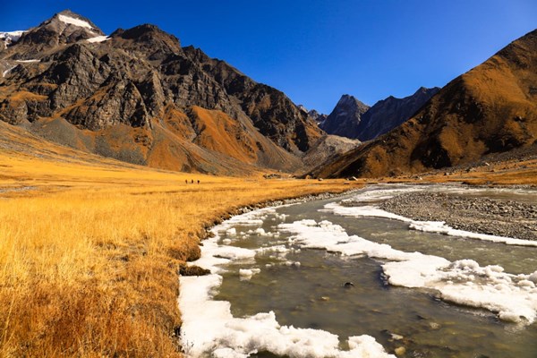
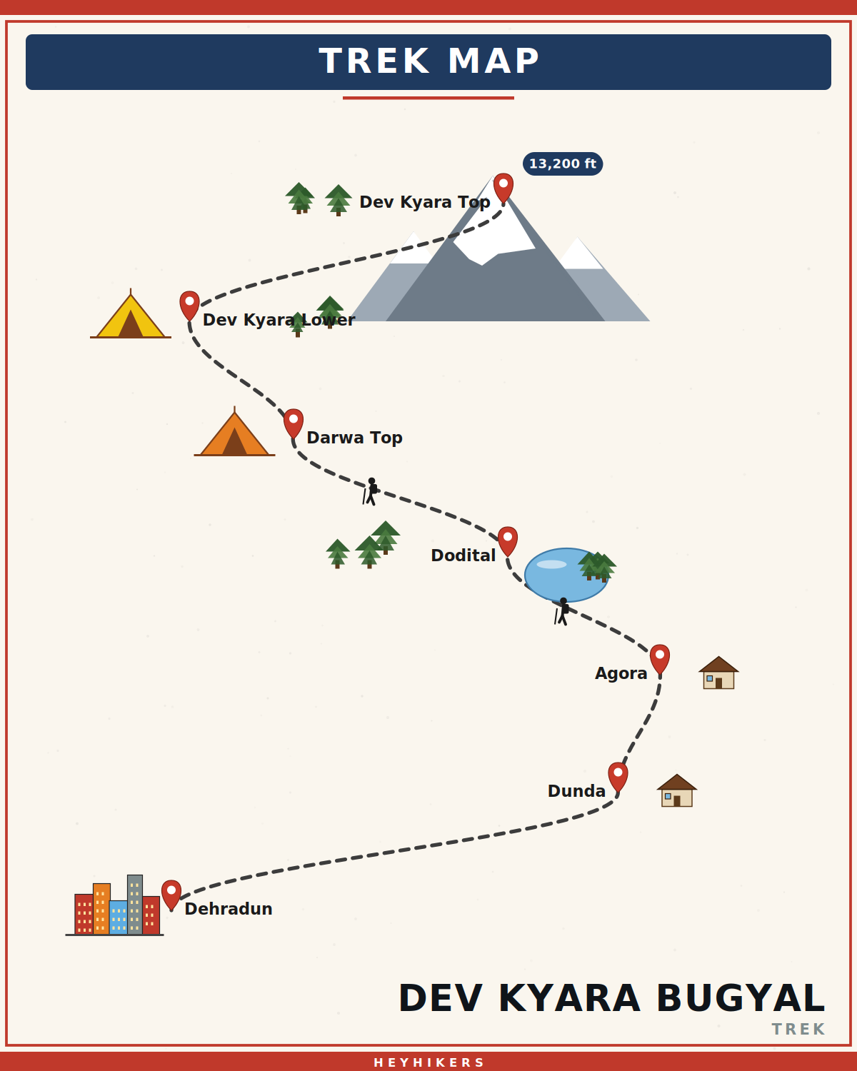
Dev Kyara is one of the largest, least-visited high-altitude meadows in Uttarakhand — a rolling grassland at 13,200 ft spread above the Asi Ganga valley in the Yamunotri range. Where the Roopkund and Ali-Bedni meadows have become standard fixtures on India's trek circuit, Dev Kyara remains an outlier: shepherds still graze sheep and water buffalo here through the summer, descendants of trader-era pack ponies still drift across the grass in small bands, and most batches of trekkers cross only one or two other groups in a week. The trek is a seven-day moderate route from Dehradun via Dunda, Agora, and the sacred lake of Dodital, climbing finally onto the bugyal proper.
The geography of the Asi Ganga catchment
Dev Kyara sits at the eastern end of the Yamunotri group — a sub-range of the Garhwal Himalayas dominated by the Bandarpoonch massif (Bandarpoonch I, 20,722 ft) and Black Peak / Kalanag (21,765 ft). The bugyal occupies a long lateral bench above the Asi Ganga, the river that drains the southern flank of Bandarpoonch into the Bhagirathi at Dunda. From the meadow's western edge you can see the entire Bandarpoonch wall in profile; from the eastern viewpoint, on a clear morning, the Gangotri group's Sudarshan Parbat and Jaonli are visible in the distance. The bugyal itself was carved by a retreating glacier roughly ten thousand years ago and is now a textbook example of a hanging meadow — flat, well-drained, and ringed by gentle 14,000 ft ridges.
The route via Dodital
The classical approach climbs from Sangam Chatti (5,200 ft) through Agora village (7,500 ft), a Garhwali hamlet famous locally as the birthplace of Olympic shooter Jaspal Rana, to the alpine lake of Dodital (10,200 ft). Dodital is a perfectly clear glacial pool ringed by spruce and rhododendron, and is sacred to Lord Ganesh — local Garhwali tradition holds it as the deity's birthplace and a small stone shrine sits at the lake's eastern end. From Dodital the trail climbs over the Darwa Pass shoulder at 12,000 ft, where the treeline gives way and the entire Bandarpoonch panorama opens, before traversing north into the Dev Kyara basin. The full distance from Dunda to the meadow and back is roughly 50 km over six walking days.
What you'll see on the meadow
Dev Kyara in early summer (late May to mid-June) is at its most photogenic — ankle-deep grass, scattered Brahma kamal and primula, and small groups of feral horses. These ponies are the genetic remnants of trade-era pack animals abandoned by Garhwali traders generations ago; the local shepherds insist they no longer recognise human handlers and keep a 50-metre buffer. From the Dev Kyara Top viewpoint at 13,200 ft you get an unbroken 180° panorama from Bandarpoonch in the west to the Gangotri peaks in the east. Sunrise here is exceptional; the meadow runs east-west and catches the first light across its full length.
Best time to trek
Dev Kyara is only reliably accessible from late May to mid-October. The early-summer window (May 15 – June 25) is the wildflower season; September and early October are post-monsoon, with the clearest skies and golden grass. July and August are monsoon — the trail is leech-prone, the river crossings are dangerous, and visibility is usually poor. Winter (November to April) sees deep snow and the bugyal is impassable.
Camping and infrastructure
The trail is rustic — there are stone shepherd huts (chaanis) on the meadow, a forest department hut at Dodital, and homestays in Agora. We camp in two-person tents on the meadow with sleeping bags rated to -5°C and a kitchen tent for hot meals. There is no mobile network past Agora; we carry a satellite communicator for emergencies. Pit toilets are provided at every camp.
Who this trek is for
Dev Kyara is a moderate trek suited to fit beginners with a tolerance for long days. The total ascent is 9,000 ft over four walking days, with the highest sleep at 13,000 ft and the highest viewpoint at 13,200 ft — modest by Himalayan standards but enough to require AMS awareness. We recommend trekkers be able to comfortably jog 5 km in 35 minutes for at least three weeks before the trek. If you've done Roopkund, Brahmatal, or Kuari Pass, this is a natural step up in remoteness without a step up in technical difficulty.
Why this trek is unique
Most Uttarakhand meadow treks (Bedni, Dayara, Phulara, Brahmatal) have been on the operator circuit for decades and now see hundreds of trekkers per peak weekend. Dev Kyara genuinely doesn't — it has remained off the catalogue partly because the approach is long and partly because the Asi Ganga valley sees fewer trekkers than the Bhagirathi or the Pindar. The result is a week on a meadow that feels closer to how the popular bugyals must have felt thirty years ago, before the trail register was a paperback.
Itinerary
Map
What trekkers say
"I'd never camped in snow before. The HeyHikers team made me feel safe every single step. The summit sunrise — standing at 12,500 ft watching peaks turn gold — I cried. Not from the cold. From the beauty."
PS
Priya Sharma
Kedarkantha, Dec 2025
"Seven lakes, each more unreal than the last. The logistics were flawless — the food at 13,000 ft was better than most restaurants I know. Our guide Farooq knew every stone on the trail. Doing Goechala with them next."
AM
Arjun Mehta
Kashmir Great Lakes, Aug 2025
Inclusion
- All meals during the trek (vegetarian, freshly cooked)
- Camping gear — tents, sleeping bags, mats
- Certified trek leader and support guides
- Forest department permits and entry fees
- First-aid kit and supplemental oxygen
- Basecamp accommodation on twin/triple sharing
Exclusion
- Travel to and from the basecamp pickup point
- Personal trekking gear and clothing
- Travel insurance covering high-altitude trekking
- Tips, personal expenses, and meals during travel days
- Anything not explicitly listed under inclusions
Things to Carry
- Trekking shoes (high-ankle, broken-in)
- 40-50L backpack with rain cover
- Two pairs of trek pants
- Three full-sleeve t-shirts (synthetic, not cotton)
- Fleece jacket and a heavier down/insulated jacket
- Thermal innerwear (top + bottom)
- Waterproof outer shell (jacket + pants)
- Woollen cap, sun cap, balaclava
- Two pairs of warm gloves (inner liner + outer)
- UV-rated sunglasses
- Headlamp with spare batteries
- Reusable water bottles (2L total) or hydration bladder
- Personal medical kit and prescription medicines
- Sunscreen (SPF 50+) and lip balm
- Toiletries and quick-dry towel
- Original photo ID (mandatory at forest checkposts)
How to Reach
Reach Dehradun. Our shared transport leaves at 6:30 AM on Day 1 and reaches Dunda (near Uttarkashi) in 6-7 hours.
Safety & Security
- Acclimatize properly — never skip rest days at altitude.
- Drink at least 4 litres of water per day above 9,000 ft.
- Tell your trek leader immediately if you feel headache, nausea, or breathlessness — early AMS signs are treatable, ignored ones are not.
- Stay close to the group; do not take shortcuts off the marked trail.
- Avoid alcohol and smoking for the entire duration of the trek.
- Keep a buffer day for travel — Himalayan roads can close without notice.
- Carry travel insurance that explicitly covers high-altitude trekking and helicopter evacuation.
Cancellation Policy
Cancellations must be requested in writing.
- More than 30 days before the trek start date: 90% refund. - 21–30 days before: 50% refund. - 11–20 days before: 25% refund. - 10 days or fewer: no refund, but you may transfer your slot to another trekker or to any future batch within 12 months at no extra charge.
Refunds are processed to the original payment method within 7-10 working days. Trip cancellations triggered by us (weather, force majeure, government restrictions) are refunded in full or moved to an alternate batch at your option.
Meet your trek leader
Akhil Deruwan
NIM Uttarkashi certified · 9 yrs experience
Akhil grew up in the foothills of the Garhwal Himalayas and has spent nearly a decade navigating its most demanding trails. He has led over 150 batches across Uttarakhand and Himachal Pradesh, with a strong focus on technical high-altitude routes and safety management. His calm under pressure and deep knowledge of local terrain make him a trusted leader for both beginner and advanced trekkers.
- Wilderness First Responder
- High Altitude Medicine
- Technical Route Navigation
- Search & Rescue
FAQ
Why Trek With Us
Travel Safe
Certified Team
Easy Cancellation
Well Equipped Campsite
Experienced Guide
No Hidden Charges