Overview
Kedartal — Shiva's Lake Beneath the North Face of Thalay Sagar
Kedartal at 15,600 ft (4,755 m) is the most demanding non-glacier alpine trek in Uttarakhand and one of the most visually arresting destinations in the entire Indian Himalayas. The eight-day route from Gangotri (10,000 ft) follows the Kedar Ganga — a small tributary of the Bhagirathi that drains the granite cirque under Mt. Thalay Sagar (22,651 ft) — through narrow gorge traverses, exposed cliff paths, and steep lateral moraine to a glacial lake ringed by some of the most striking granite spires in the Himalayas. Where Roopkund offers mystery and Gaumukh Tapovan offers scale, Kedartal offers verticality: the north face of Thalay Sagar rises 7,000 feet directly above the far shore of the lake in a single uninterrupted granite wall.
Why this trek is unique
Three factors set Kedartal apart from comparable Garhwal lake treks. First, the peak architecture: Thalay Sagar's north face is one of the great granite walls of the world, comparable to the Trango Towers in scale and sustained verticality. It was first climbed in 1979 by an Indo-American team led by Roy Kligfield, and has since seen only a handful of repeats. Second, the trail itself: rather than the typical meadow-to-meadow walk of most Uttarakhand routes, Kedartal traverses a narrow gorge with several exposed cliff sections cut into the rock — these are the trek's most psychologically demanding stretches and the reason the route is graded difficult. Third, the religious context: Kedartal is one of Lord Shiva's traditional resting places (Kedar = Shiva, Tal = lake), and the small puja platform at the lake's southern shore still receives offerings from Hindu pilgrims who reach this altitude.
The route from Gangotri
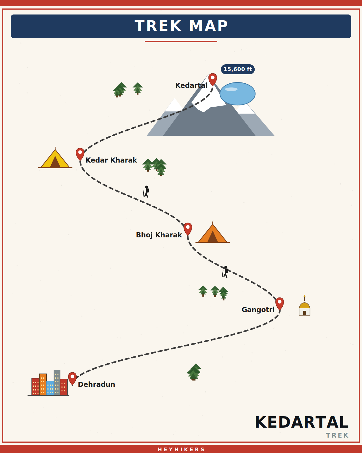
The trek begins at the Gangotri temple complex (10,000 ft) — an 18th-century shrine built by Gorkha general Amar Singh Thapa where the goddess Ganga is said to have descended to earth. Day 2 is a mandatory acclimatization rest day with a short hike to Pandava Gufa cave (10,400 ft). Day 3 climbs through chir pine, deodar, and Himalayan birch (bhojpatra) along exposed traverses above the Kedar Ganga gorge to Bhoj Kharak (12,300 ft). Day 4 climbs above the treeline through alpine moraine to Kedar Kharak (14,200 ft), with the first uninterrupted view of Thalay Sagar at the head of the valley. Day 5 is the centrepiece: a pre-dawn day-hike to the lake at 15,600 ft and back to camp. Days 6-8 retrace the descent through Bhoj Kharak to Gangotri, then drive back to Dehradun.
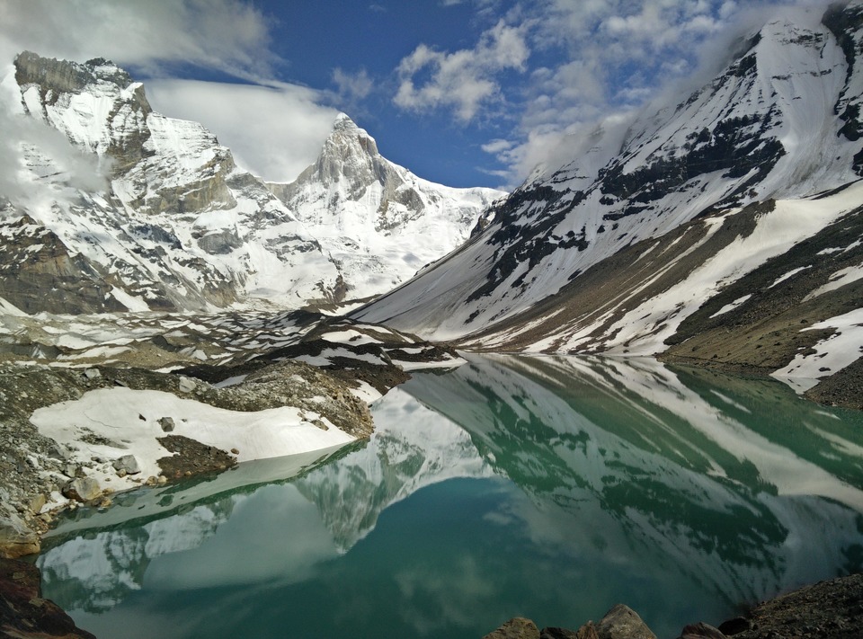
The lake and the panorama
The lake itself is a perfect glacial pool ringed by moraine, with the colossal north face of Mt. Thalay Sagar (22,651 ft) rising directly above the far shore. To the south stand Bhrigupanth (22,313 ft) and Jogin I-III (20,000+ ft); to the north, the unnamed satellite peaks of the Gangotri group. The lake's water is a clear green-blue and freezes solid in winter; in summer the surface mirrors Thalay Sagar perfectly. Many trekkers describe Kedartal as the most spiritually charged place they have stood in — the combination of altitude, the still water, and the granite wall creates a contemplative atmosphere that is hard to find on busier trails.
Best season and conditions
Kedartal has two windows. Mid-May to late June brings clear skies, mild temperatures, and snow-free moraines. September to mid-October is post-monsoon, with the clearest views of the year and crisp golden meadows. The monsoon (July-August) closes the trail — landslides on the exposed Kedar Ganga gorge traverses are dangerous and the cliff sections become slippery. November onwards the upper sections snow over and Kedartal becomes inaccessible. Daytime temperatures range from 15°C in lower forests to -5°C at Kedar Kharak; nights at the high camp can drop to -10°C even in summer.
Difficulty and prerequisites
Kedartal is graded difficult — one full grade above standard Garhwal lake treks. The exposed cliff traverses below Bhoj Kharak require sure-footed movement and a head for heights; the lateral moraine ascent above Kedar Kharak passes through an unstable scree section under a hanging cliff. We require prior trekking experience above 14,000 ft (Hampta Pass, Buran Ghati, or Roopkund minimum) and cardiovascular fitness equivalent to running 5 km in 30 minutes. Anyone with a history of vertigo, knee instability, or untreated cardiac conditions should not attempt this trek. The Day 2 acclimatization rest at Gangotri is non-negotiable — most cases of AMS on this route come from trekkers who push past it.
Camping, gear, and permits
Kedartal sits inside the Gangotri National Park, a protected area with strict daily entry caps. Each trekker requires a personal permit (issued at the Uttarkashi forest office or at Gangotri) which we apply for two weeks in advance. The permit is non-transferable and must be carried for the entire trek. HeyHikers operates designated forest-department-permitted campsites at Bhoj Kharak and Kedar Kharak with four-season tents, sleeping bags rated to -15°C, kitchen tents, and pit toilets. Mules cannot ascend beyond Bhoj Kharak — group gear above that is portered. Mobile network ends at Gangotri.
Cultural and historical context
The Kedar Ganga has been walked by Hindu sadhus for at least a thousand years; the small Shiva platform at the lake is mentioned in the Skanda Purana as one of the deity's resting sites between his Kedarnath and Manasarovar abodes. The route was scouted in modern recorded form by the British surveyor T.G. Montgomerie in the 1860s and was a regular destination for the small group of British and Bengali mountaineers who explored the Gangotri basin in the early twentieth century. The neighbouring Bhagirathi peaks and Mt. Shivling were named by these surveyors using the Sanskrit nomenclature suggested by local pandits at Gangotri.
Itinerary
Map
What trekkers say
"I'd never camped in snow before. The HeyHikers team made me feel safe every single step. The summit sunrise — standing at 12,500 ft watching peaks turn gold — I cried. Not from the cold. From the beauty."
PS
Priya Sharma
Kedarkantha, Dec 2025
"Seven lakes, each more unreal than the last. The logistics were flawless — the food at 13,000 ft was better than most restaurants I know. Our guide Farooq knew every stone on the trail. Doing Goechala with them next."
AM
Arjun Mehta
Kashmir Great Lakes, Aug 2025
Inclusion
- All meals during the trek (vegetarian, freshly cooked)
- Camping gear — tents, sleeping bags, mats
- Certified trek leader and support guides
- Forest department permits and entry fees
- First-aid kit and supplemental oxygen
- Basecamp accommodation on twin/triple sharing
Exclusion
- Travel to and from the basecamp pickup point
- Personal trekking gear and clothing
- Travel insurance covering high-altitude trekking
- Tips, personal expenses, and meals during travel days
- Anything not explicitly listed under inclusions
Things to Carry
- Trekking shoes (high-ankle, broken-in)
- 40-50L backpack with rain cover
- Two pairs of trek pants
- Three full-sleeve t-shirts (synthetic, not cotton)
- Fleece jacket and a heavier down/insulated jacket
- Thermal innerwear (top + bottom)
- Waterproof outer shell (jacket + pants)
- Woollen cap, sun cap, balaclava
- Two pairs of warm gloves (inner liner + outer)
- UV-rated sunglasses
- Headlamp with spare batteries
- Reusable water bottles (2L total) or hydration bladder
- Personal medical kit and prescription medicines
- Sunscreen (SPF 50+) and lip balm
- Toiletries and quick-dry towel
- Original photo ID (mandatory at forest checkposts)
How to Reach
Reach Dehradun. Our shared transport leaves at 6:00 AM on Day 1 and reaches Gangotri in 11 hours via Uttarkashi and Harsil. Day 2 is a mandatory acclimatization day at Gangotri (10,000 ft).
Safety & Security
- Acclimatize properly — never skip rest days at altitude.
- Drink at least 4 litres of water per day above 9,000 ft.
- Tell your trek leader immediately if you feel headache, nausea, or breathlessness — early AMS signs are treatable, ignored ones are not.
- Stay close to the group; do not take shortcuts off the marked trail.
- Avoid alcohol and smoking for the entire duration of the trek.
- Keep a buffer day for travel — Himalayan roads can close without notice.
- Carry travel insurance that explicitly covers high-altitude trekking and helicopter evacuation.
Cancellation Policy
Cancellations must be requested in writing.
- More than 30 days before the trek start date: 90% refund. - 21–30 days before: 50% refund. - 11–20 days before: 25% refund. - 10 days or fewer: no refund, but you may transfer your slot to another trekker or to any future batch within 12 months at no extra charge.
Refunds are processed to the original payment method within 7-10 working days. Trip cancellations triggered by us (weather, force majeure, government restrictions) are refunded in full or moved to an alternate batch at your option.
Meet your trek leader
Akhil Deruwan
NIM Uttarkashi certified · 9 yrs experience
Akhil grew up in the foothills of the Garhwal Himalayas and has spent nearly a decade navigating its most demanding trails. He has led over 150 batches across Uttarakhand and Himachal Pradesh, with a strong focus on technical high-altitude routes and safety management. His calm under pressure and deep knowledge of local terrain make him a trusted leader for both beginner and advanced trekkers.
- Wilderness First Responder
- High Altitude Medicine
- Technical Route Navigation
- Search & Rescue
FAQ
Why Trek With Us
Travel Safe
Certified Team
Easy Cancellation
Well Equipped Campsite
Experienced Guide
No Hidden Charges