Overview
Pangarchulla Peak — A True Garhwal Summit
Pangarchulla Peak at 14,700 ft (4,480 m) is the natural step up from Kuari Pass for trekkers ready to attempt their first real Himalayan summit. The route shares the first three days with Kuari — Joshimath, Dhak, and the Khullara meadow — but on the fourth day it diverges sharply: while Kuari trekkers head to a 12,500 ft saddle, Pangarchulla trekkers tackle an alpine-style pre-dawn push up a 2,000 ft snow slope to a true mountain summit. The reward is one of the broadest 360° panoramas in Garhwal: Nanda Devi (25,646 ft), Dronagiri (23,184 ft), Hathi-Ghoda, the Chaukhamba massif (23,419 ft), Kamet (25,446 ft), and Trishul (23,360 ft) — all visible from a single summit boulder.
What makes Pangarchulla special
Most "summit treks" in India are technically false summits or temple-topped highpoints. Pangarchulla is a real peak — a sharp triangular point on the southern wall of the Nanda Devi sanctuary buffer, requiring snow climbing, ridgework, and a 4 AM start. It is not a graded mountaineering objective (no IMF permit needed), but it sits firmly between trekking and mountaineering. The summit day involves microspikes, ice axes (provided), and rope-fixed sections on the upper boulder ridge. For trekkers who have completed Kuari, Roopkund, or Hampta and want the next step, Pangarchulla is the textbook progression.
The route from Joshimath
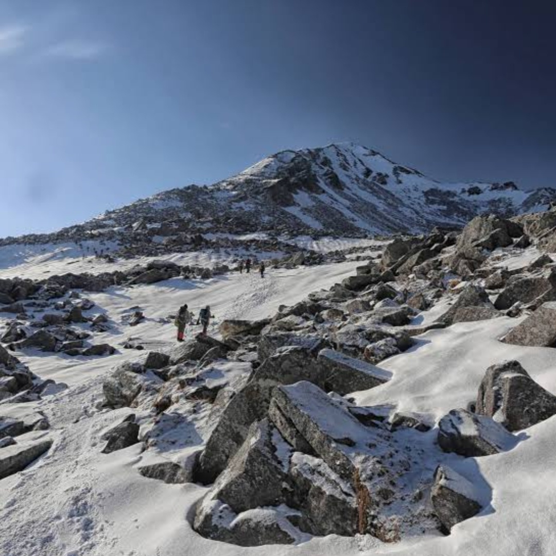
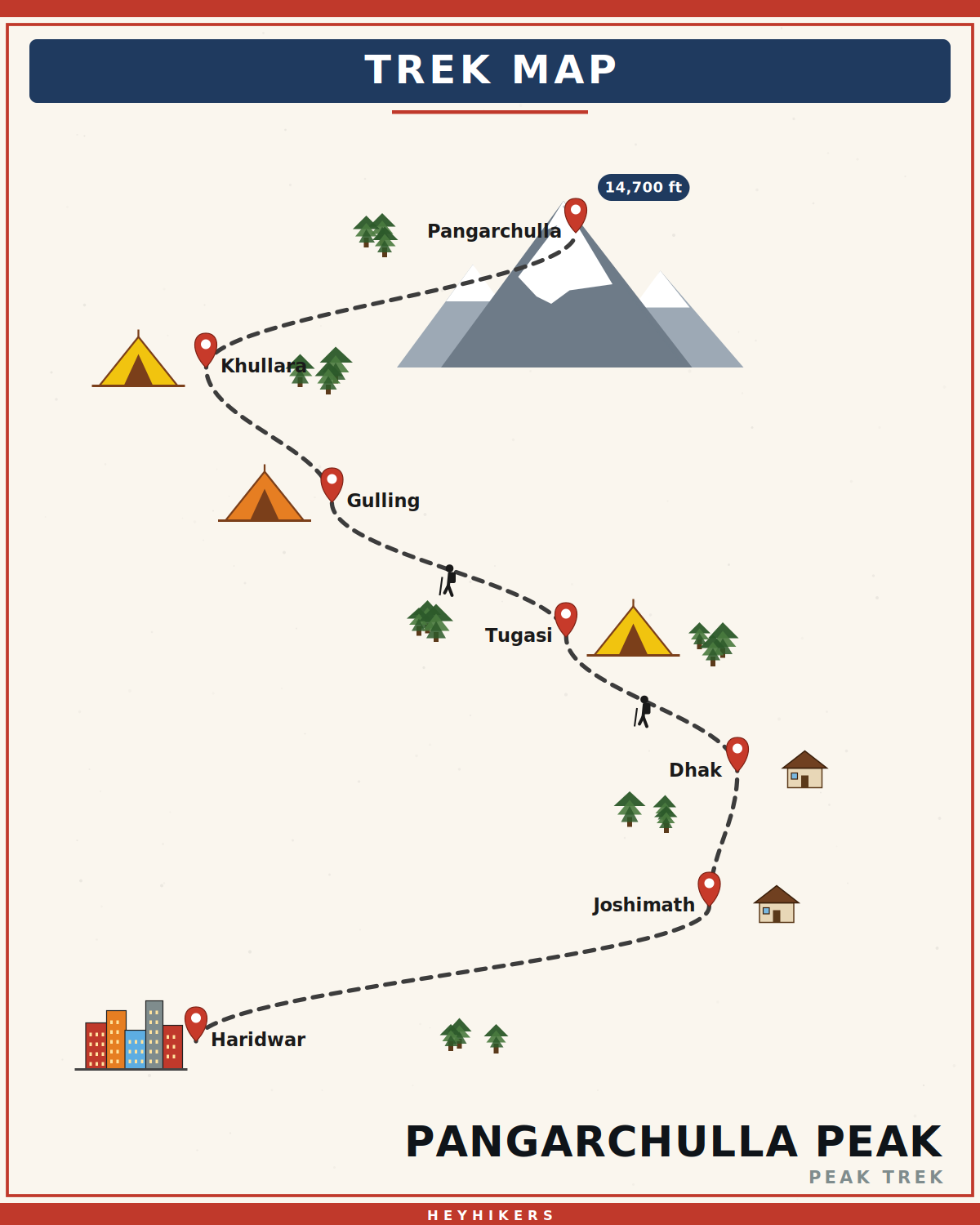
The trail begins at Dhak village (6,800 ft), 12 km drive from Joshimath. Day 2 climbs through apple orchards and Tugasi village to Gulling at 9,500 ft. Day 3 ascends to Khullara meadow (11,200 ft) — a vast alpine bowl where the panorama first reveals itself. Day 4 is summit day: a 4 AM departure, a 4 km traverse to the peak base, a snow climb to the upper boulder ridge, and the final scramble to the summit at 14,700 ft. Most groups reach the summit by 9-10 AM, descend to Khullara by 3 PM. Day 5 descends to Joshimath; Day 6 drives back to Haridwar.
The summit day in detail
Wake-up at 3 AM. Hot porridge and tea by 3:30. On the trail by 4 AM with headlamps. The first 90 minutes is a moderate snow-climb across a wide bowl above Khullara. By 6 AM you reach the boulder ridge — a 500 m granite ridge that climbs at 35° to the summit pyramid. We fix a rope on the steepest 200 m section and trekkers ascend with safety harnesses. The final 100 m is a scramble over loose boulders to the summit. Total summit-day distance: 12 km. Elevation gain: 3,500 ft. Elevation loss: 3,500 ft (descent same day). Many trekkers describe this as the hardest single day they have done.
Best season
Two windows. April-May is the snow-climb season — 3-5 feet of compact snow on the upper boulder ridge, microspikes are essential, the climb is more interesting and feels like real mountaineering. September-October is the dry season — boulders are exposed, less snow, the climb is more scrambling than snow work. The pre-monsoon (April-May) is generally preferred for the visual experience. Avoid June (pre-monsoon storms), July-August (monsoon), and November (deep snow, summit unreachable).
Difficulty and prerequisites
This is graded difficult — one full grade above Kuari Pass. Prerequisites: at least one prior trek above 12,000 ft (Kuari, Roopkund, or similar), ability to walk 12 km on uneven terrain in a day, and cardiovascular fitness equivalent to running 5 km in 30 minutes. We require a fitness video and prior-trek certificates as part of enrolment. We do NOT take complete beginners — Pangarchulla is one of those treks where insufficient fitness or prior altitude exposure can result in a summit-day evacuation.
Camping and infrastructure
Camps at Gulling (Day 2) and Khullara (Days 3-4). Both are forest-department-permitted designated sites; we provide two-person tents, sleeping bags rated to -10°C, kitchen tents, pit toilets, and mules carrying group gear. You carry only a 5-7 kg daypack. Joshimath has hotels, ATMs, hospitals, and BSNL/Jio mobile network. Beyond Joshimath, no signal until you return.
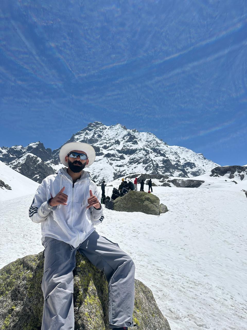
What you'll see at the summit
The Pangarchulla summit looks straight into the heart of the Nanda Devi sanctuary, a UNESCO biosphere reserve closed to trekking since the 1980s due to mountaineering accidents and conservation concerns. From the summit you can see Nanda Devi East (24,389 ft) on the right, the main Nanda Devi (25,646 ft) peak slightly west of it, and the rim of inner sanctuary peaks: Changabang, Kalanka, Dunagiri. The view extends west to Chaukhamba and east to Kamet on the Tibetan border. On rare days, you can see the upper Rishi Ganga gorge — the famous valley first crossed by Eric Shipton and Bill Tilman in 1934 and now closed to all access.
Itinerary
Map
What trekkers say
"I'd never camped in snow before. The HeyHikers team made me feel safe every single step. The summit sunrise — standing at 12,500 ft watching peaks turn gold — I cried. Not from the cold. From the beauty."
PS
Priya Sharma
Kedarkantha, Dec 2025
"Seven lakes, each more unreal than the last. The logistics were flawless — the food at 13,000 ft was better than most restaurants I know. Our guide Farooq knew every stone on the trail. Doing Goechala with them next."
AM
Arjun Mehta
Kashmir Great Lakes, Aug 2025
Inclusion
- All meals during the trek (vegetarian, freshly cooked)
- Camping gear — tents, sleeping bags, mats
- Certified trek leader and support guides
- Forest department permits and entry fees
- First-aid kit and supplemental oxygen
- Basecamp accommodation on twin/triple sharing
Exclusion
- Travel to and from the basecamp pickup point
- Personal trekking gear and clothing
- Travel insurance covering high-altitude trekking
- Tips, personal expenses, and meals during travel days
- Anything not explicitly listed under inclusions
Things to Carry
- Trekking shoes (high-ankle, broken-in)
- 40-50L backpack with rain cover
- Two pairs of trek pants
- Three full-sleeve t-shirts (synthetic, not cotton)
- Fleece jacket and a heavier down/insulated jacket
- Thermal innerwear (top + bottom)
- Waterproof outer shell (jacket + pants)
- Woollen cap, sun cap, balaclava
- Two pairs of warm gloves (inner liner + outer)
- UV-rated sunglasses
- Headlamp with spare batteries
- Reusable water bottles (2L total) or hydration bladder
- Personal medical kit and prescription medicines
- Sunscreen (SPF 50+) and lip balm
- Toiletries and quick-dry towel
- Original photo ID (mandatory at forest checkposts)
How to Reach
Reach Haridwar by train or road. Our shared transport leaves Haridwar Railway Station at 6:00 AM on Day 1 and reaches Joshimath in 10-12 hours via Rishikesh, Devprayag, and Rudraprayag.
Safety & Security
- Acclimatize properly — never skip rest days at altitude.
- Drink at least 4 litres of water per day above 9,000 ft.
- Tell your trek leader immediately if you feel headache, nausea, or breathlessness — early AMS signs are treatable, ignored ones are not.
- Stay close to the group; do not take shortcuts off the marked trail.
- Avoid alcohol and smoking for the entire duration of the trek.
- Keep a buffer day for travel — Himalayan roads can close without notice.
- Carry travel insurance that explicitly covers high-altitude trekking and helicopter evacuation.
Cancellation Policy
Cancellations must be requested in writing.
- More than 30 days before the trek start date: 90% refund. - 21–30 days before: 50% refund. - 11–20 days before: 25% refund. - 10 days or fewer: no refund, but you may transfer your slot to another trekker or to any future batch within 12 months at no extra charge.
Refunds are processed to the original payment method within 7-10 working days. Trip cancellations triggered by us (weather, force majeure, government restrictions) are refunded in full or moved to an alternate batch at your option.
Meet your trek leader
Akhil Deruwan
NIM Uttarkashi certified · 9 yrs experience
Akhil grew up in the foothills of the Garhwal Himalayas and has spent nearly a decade navigating its most demanding trails. He has led over 150 batches across Uttarakhand and Himachal Pradesh, with a strong focus on technical high-altitude routes and safety management. His calm under pressure and deep knowledge of local terrain make him a trusted leader for both beginner and advanced trekkers.
- Wilderness First Responder
- High Altitude Medicine
- Technical Route Navigation
- Search & Rescue
FAQ
Why Trek With Us
Travel Safe
Certified Team
Easy Cancellation
Well Equipped Campsite
Experienced Guide
No Hidden Charges