Overview
Phulara Ridge — The Trek Where You Walk the Ridge Instead of Crossing It
Phulara Ridge at 12,100 ft (3,690 m) is one of the rarest geometries in Indian Himalayan trekking: a route whose climax is not a summit, not a saddle, and not a lake — but a three-kilometre flat ridgeline that you walk along for an entire day. From a single, unbroken alpine spine in the upper Tons valley, the trail traces the watershed between the Supin and Obra Gad drainages with 360° views of the Bandarpoonch (20,719 ft), Kalanag / Black Peak (20,725 ft), and Swargarohini I-IV (21,000+ ft) massifs visible for almost every step. It is the only trek in Garhwal where the most photogenic moment is not a five-minute summit but a four-hour walk.
Why this trek is unique
Most Himalayan treks deal with ridges by crossing them perpendicularly — climb up one side, snap a photo at the col, descend the other side in 30 minutes. Phulara takes the opposite approach. The trail climbs through forest and meadows for three days, gains the western end of the ridge on Day 4 morning, and then walks east along the ridgetop for 3-4 hours before descending into a sheltered camp on the far side. The geometry produces an experience that is simultaneously panoramic and almost entirely flat — anyone who has trekked the Cuillin in Skye or the Crib Goch in Wales will recognise the format, but Phulara is gentler, wider, and crucially safer than those exposed scrambles.
The geography of the upper Tons
The Phulara Ridge lies in the heart of Govind Pashu Vihar Wildlife Sanctuary in Uttarkashi district, between the Supin river (the Har Ki Dun tributary) and the Obra Gad. The ridge runs east-west for roughly 3 km at a near-uniform 12,100 ft, dropping sharply on both sides — north into the Supin gorge and south toward the Obra Gad. The ridge is what geomorphologists call an arête — a sharp ridge formed when two glacial valleys eroded a mountain mass from opposite sides. Sankri (6,400 ft), the basecamp village, is the same trailhead used for Kedarkantha, Har Ki Dun, and Bali Pass; Phulara shares the lower approach with Har Ki Dun for the first day before branching off near Pauni Garaat.
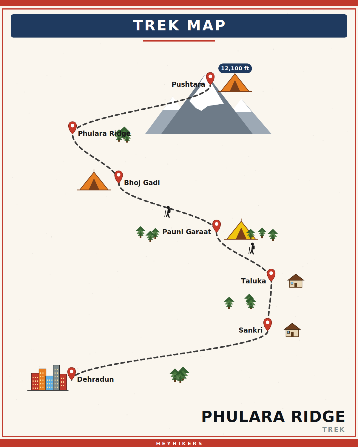
The route from Sankri
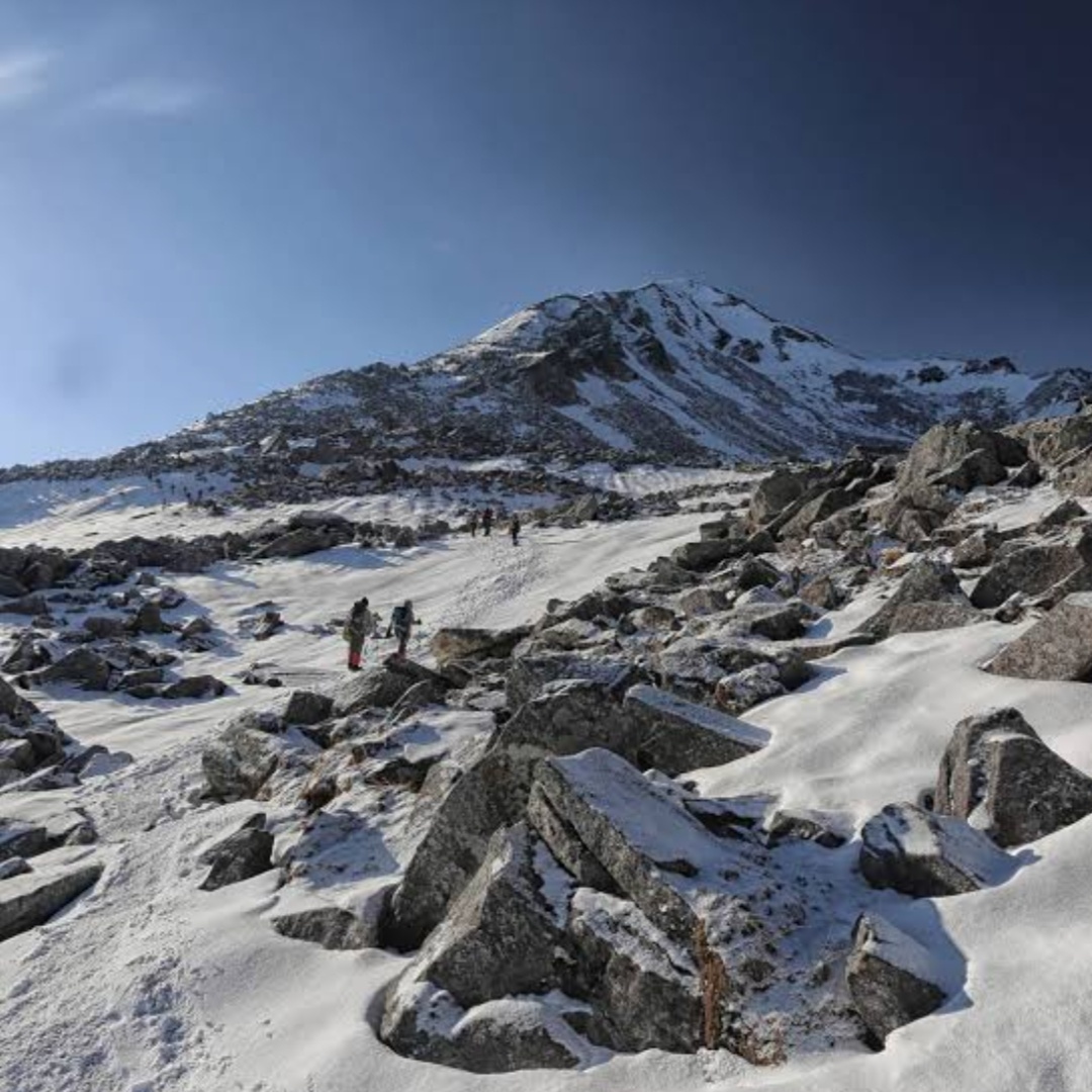
The trek begins with the Bolero ride from Sankri to Taluka (7,200 ft) — 12 km of teeth-rattling road through deodar forest. From Taluka the trail follows the Supin river upstream for 4 km to Pauni Garaat (8,000 ft), the first night's camp. Day 3 climbs through Kotgaon village and old-growth oak-rhododendron forest to the meadow camp at Bhoj Gadi (10,500 ft). Day 4 is the signature day — a steep 90-minute climb to the western end of the ridge, then a 3 km walk east along the ridgetop with views of Bandarpoonch, Kalanag, Swargarohini, and the Tons valley spread out 6,000 ft below, ending at Pushtara campsite (11,300 ft). Day 5 is the long descent through pine and oak to Taluka and back to Sankri.
The ridge walk in detail
The 3 km ridge traverse is wide enough that even nervous trekkers feel comfortable — typically 5-10 metres of walkable grass at the top, with gentle drops on either side rather than the cliff-edge exposure of, say, the Crib Goch. The path is grass-on-rock, well-drained, and rarely snowy except in early April. The eastern terminus is marked by a small cairn and prayer flags at the trek's high point of 12,100 ft. We walk slowly with multiple stops for photography — most groups take 3-4 hours to cover the 3 km.
Best season
Phulara runs in two windows. April-May is rhododendron season — the lower forests are a red-pink canopy of Himalayan rhododendron arboreum, and the ridge is largely snow-free with patchy spring snow on the northern shadows. October-mid November is post-monsoon — golden meadow grass, frosty mornings, and the clearest air of the year, with views of distant peaks (sometimes including Nanda Devi 200 km away) at their best. We also run select winter (December-January) batches as a snow trek when the ridge is buried under 2-3 feet of snow and microspikes are mandatory. Monsoon (July-August) is closed.
Difficulty and prerequisites
Phulara is graded easy — total trekking is about 30 km over four walking days, with a high point of 12,100 ft. Daily distances are short (4-8 km). Sleeping altitudes are moderate. Suitable for first-time Himalayan trekkers, families with children 12+, and older trekkers in reasonable health. The Day 4 ridge walk is gentle in gradient but exposed to wind — we plan it for mid-morning when the wind is typically calmer. Cardiovascular fitness equivalent to running 5 km in 35 minutes is sufficient.
Camping and infrastructure
The trek uses three camps: Pauni Garaat (forest), Bhoj Gadi (meadow), and Pushtara (sheltered alpine bowl). All three are designated Forest Department-permitted sites; we provide two-person tents, sleeping bags rated to -10°C, kitchen tents with full-time cooks, pit toilets, and mules carrying group gear. The pre- and post-trek nights are spent in a clean Sankri guesthouse with twin-sharing rooms, hot bucket water, and home-cooked Garhwali meals. Mobile network (BSNL/Jio) is available at Sankri but absent on the trail.
Who this trek is for
Phulara is the textbook second Himalayan trek. If you have done one easy trek (Triund, Kedarkantha summer, Nag Tibba) and want something a step up — slightly longer, slightly higher, and visually more rewarding — Phulara is the natural progression. We also see retirees, photographers, and family groups on every batch. Many trekkers explicitly choose Phulara over Kedarkantha because it is much less crowded and the ridge experience is genuinely unique.
Cultural context
The trek passes through Kotgaon village, a Garhwali hamlet whose households still practice the centuries-old wool-and-rajma economy that defined the upper Tons valley before road access. The Govind Pashu Vihar sanctuary itself was created in 1955 to protect snow leopard, Himalayan brown bear, and Himalayan tahr — sightings are rare but the sanctuary's bird life (Himalayan monal, koklass pheasant, Himalayan griffon vulture) is excellent on the ridge in clear weather.
Itinerary
Map
What trekkers say
"I'd never camped in snow before. The HeyHikers team made me feel safe every single step. The summit sunrise — standing at 12,500 ft watching peaks turn gold — I cried. Not from the cold. From the beauty."
PS
Priya Sharma
Kedarkantha, Dec 2025
"Seven lakes, each more unreal than the last. The logistics were flawless — the food at 13,000 ft was better than most restaurants I know. Our guide Farooq knew every stone on the trail. Doing Goechala with them next."
AM
Arjun Mehta
Kashmir Great Lakes, Aug 2025
Inclusion
- All meals during the trek (vegetarian, freshly cooked)
- Camping gear — tents, sleeping bags, mats
- Certified trek leader and support guides
- Forest department permits and entry fees
- First-aid kit and supplemental oxygen
- Basecamp accommodation on twin/triple sharing
Exclusion
- Travel to and from the basecamp pickup point
- Personal trekking gear and clothing
- Travel insurance covering high-altitude trekking
- Tips, personal expenses, and meals during travel days
- Anything not explicitly listed under inclusions
Things to Carry
- Trekking shoes (high-ankle, broken-in)
- 40-50L backpack with rain cover
- Two pairs of trek pants
- Three full-sleeve t-shirts (synthetic, not cotton)
- Fleece jacket and a heavier down/insulated jacket
- Thermal innerwear (top + bottom)
- Waterproof outer shell (jacket + pants)
- Woollen cap, sun cap, balaclava
- Two pairs of warm gloves (inner liner + outer)
- UV-rated sunglasses
- Headlamp with spare batteries
- Reusable water bottles (2L total) or hydration bladder
- Personal medical kit and prescription medicines
- Sunscreen (SPF 50+) and lip balm
- Toiletries and quick-dry towel
- Original photo ID (mandatory at forest checkposts)
How to Reach
Reach Dehradun. Our shared transport leaves Prince Chowk at 6:30 AM on Day 1 and reaches Sankri in 9-10 hours via Mussoorie and Mori.
Safety & Security
- Acclimatize properly — never skip rest days at altitude.
- Drink at least 4 litres of water per day above 9,000 ft.
- Tell your trek leader immediately if you feel headache, nausea, or breathlessness — early AMS signs are treatable, ignored ones are not.
- Stay close to the group; do not take shortcuts off the marked trail.
- Avoid alcohol and smoking for the entire duration of the trek.
- Keep a buffer day for travel — Himalayan roads can close without notice.
- Carry travel insurance that explicitly covers high-altitude trekking and helicopter evacuation.
Cancellation Policy
Cancellations must be requested in writing.
- More than 30 days before the trek start date: 90% refund. - 21–30 days before: 50% refund. - 11–20 days before: 25% refund. - 10 days or fewer: no refund, but you may transfer your slot to another trekker or to any future batch within 12 months at no extra charge.
Refunds are processed to the original payment method within 7-10 working days. Trip cancellations triggered by us (weather, force majeure, government restrictions) are refunded in full or moved to an alternate batch at your option.
Meet your trek leader
Akhil Deruwan
NIM Uttarkashi certified · 9 yrs experience
Akhil grew up in the foothills of the Garhwal Himalayas and has spent nearly a decade navigating its most demanding trails. He has led over 150 batches across Uttarakhand and Himachal Pradesh, with a strong focus on technical high-altitude routes and safety management. His calm under pressure and deep knowledge of local terrain make him a trusted leader for both beginner and advanced trekkers.
- Wilderness First Responder
- High Altitude Medicine
- Technical Route Navigation
- Search & Rescue
FAQ
Why Trek With Us
Travel Safe
Certified Team
Easy Cancellation
Well Equipped Campsite
Experienced Guide
No Hidden Charges