Overview
Rupin Pass — Eight Days, Three States, and the Three-Stage Waterfall
Rupin Pass at 15,279 ft (4,657 m) is the most varied long crossover trek in the Indian Himalayas. Across eight days the trail walks you out of Dhaula village in Uttarakhand, through a fold of forested ridges into Himachal Pradesh, past a three-stage glacial waterfall said to be the trek's signature image, up a 60-degree snow wall to the pass, and down into the apple-orchard town of Sangla in the Kinnaur district. There is no other Indian trek that crosses three administrative units (Uttarakhand, Himachal, Kinnaur) and presents such a sequence of distinct landscapes — terraced barley fields, deodar forest, hanging glaciers, snow-walled passes, and Kinnauri Buddhist villages — in a single continuous walk.
The geography of the crossing
Rupin Pass sits on the main Dhauladhar-Pir Panjal divide, separating the upper Tons drainage (Yamuna basin) from the upper Sutlej drainage. The Tons-side approach (Days 1-5) traces the Rupin river upstream through a long, deep U-shaped glacial valley — the river and its tributaries have carved successive shelves, each shelf a flat camping pasture, and the elevation gain is gradual. The Sangla-side descent (Days 6-8) drops you sharply into the Baspa river valley with its prosperous Kinnauri villages, apple orchards, and the cantilevered pagoda temples typical of Indo-Tibetan architecture.
The route from Dhaula
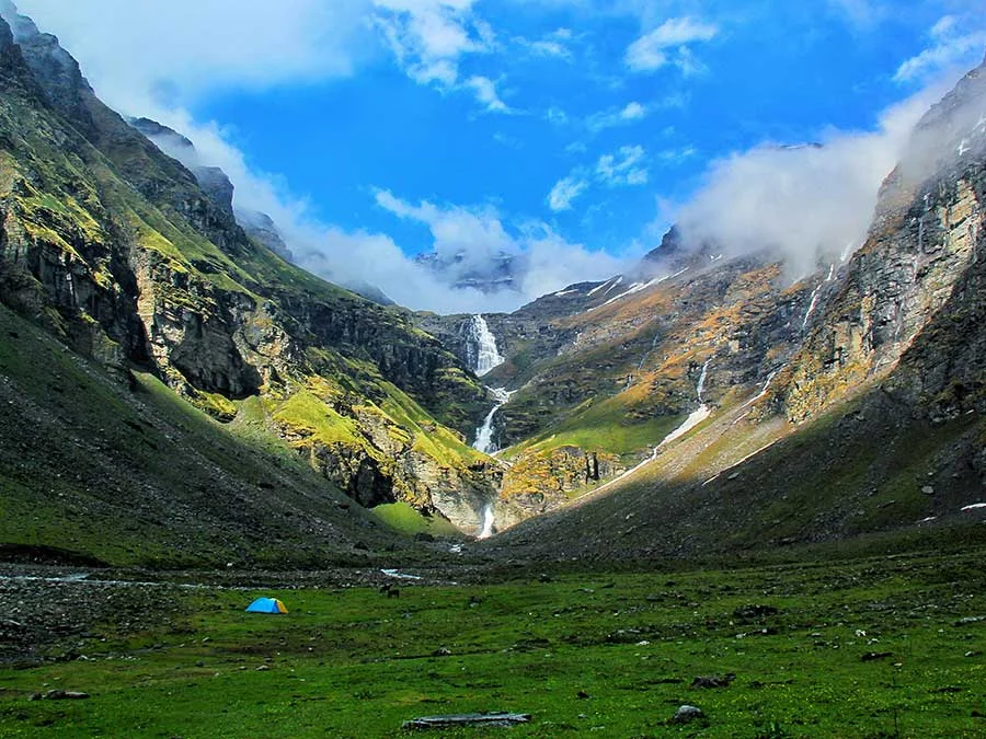
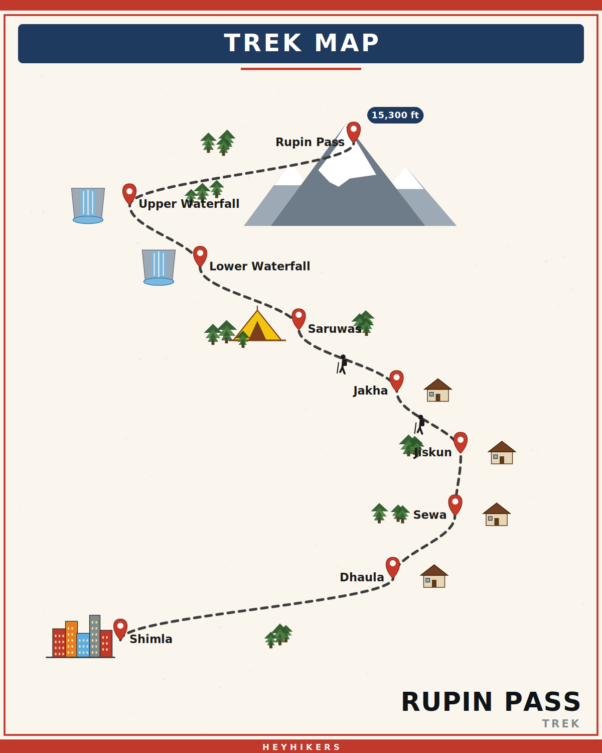
The trek begins at Dhaula (5,100 ft), a Garhwali roadhead village. Day 1 climbs through terraced fields and pine forest to Sewa village (6,200 ft), famous for its 1,500-year-old wooden Kali temple and a unique tradition of shared marriage rights with neighbouring Jakha. Days 2-3 cross into Himachal Pradesh through Jhaka — the "hanging village" perched on a cliff — and climb through old-growth pine to Saruwas Thach (11,200 ft), a wide alpine meadow used by Gaddi shepherds. Day 4 traces the Rupin upstream past the famous three-stage waterfall — a glacial cascade that drops in three distinct tiers visible from a single vantage — to Dhanderas Thach (11,700 ft), often called the "lower waterfall camp". Day 5 climbs to Upper Waterfall Camp (13,100 ft), set directly above the cascade.
Pass day and the snow wall
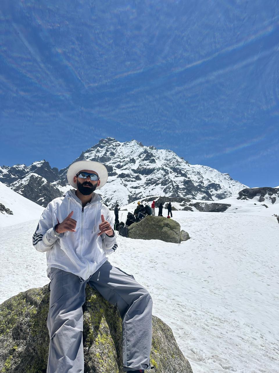
Day 6 is summit day. A 3 AM start under headlamps, an hour of moraine climbing, and the trail reaches the foot of the famous "snow wall" — a 60-degree compact snow ramp roughly 200 metres in length that leads to the pass. We fix two ropes and issue microspikes; trekkers ascend with hand-line for safety. The wall is non-technical but sustained — most trekkers report it as the hardest sustained climb they have done. The pass itself is a narrow saddle marked by cairns and prayer flags. From the top the views span the Kinner Kailash range to the east, the Pir Panjal to the north, and the upper Garhwal peaks behind you. The descent on the Sangla side is on a long snow ramp that allows for a controlled glissade — the photographic complement to the wall climb. The day ends at Ronti Gad (13,100 ft).
Best season and weather
Rupin Pass runs in two distinct windows: mid-May to late June for the snow-wall season (firm spring snow, full glissade descent, frozen waterfalls thawing) and September to mid-October for the dry crossing (no rope on the wall, walking down loose scree, autumn colours in the Kinnaur villages). Most trekkers prefer the May-June window for the snow-wall photo. Monsoon (July-August) is unsafe due to landslides on the Tons-side approach and is not run.
Camping and infrastructure
HeyHikers operates a fixed-camp model with two-person tents, sleeping bags rated to -10°C, communal kitchen, and dry pit toilets at all six high camps. The Day 1 night is in a Sewa homestay; Day 8 is a Sangla guesthouse. We carry fixed ropes, microspikes, and ice axes for the pass. Mules carry load to Saruwas Thach; above that the gear is portered. Mobile network ends at Sewa and resumes at Sangla.
Difficulty and prerequisites
Rupin is graded moderate-to-difficult. Required: prior experience of one Himalayan trek above 12,000 ft (Hampta Pass, Sar Pass, Kedarkantha qualify) and ability to run 5 km in 30 minutes. The pass-day total is 12-14 hours and is the longest single day on the trek. Trekkers with knee instability should be aware that the cumulative descent from pass to Sangla is over 9,000 ft across two days.
Cultural and historical context
The Rupin route was a working salt-trade corridor between Tibet and the Yamuna valley until the 1962 Sino-Indian war closed the border. The villages of Sewa and Jakha share a unique shared-marriage tradition in which a bride from one village is considered the wife of all brothers in the household — a polyandrous custom now rare in India but still observed in these remote Tons valley settlements. The Sangla-side villages of Sangla and Chitkul are Indo-Tibetan and Buddhist; Chitkul, eighteen kilometres east of Sangla, is the last Indian village before the China border and is a recommended day trip.
Itinerary
Map
What trekkers say
"I'd never camped in snow before. The HeyHikers team made me feel safe every single step. The summit sunrise — standing at 12,500 ft watching peaks turn gold — I cried. Not from the cold. From the beauty."
PS
Priya Sharma
Kedarkantha, Dec 2025
"Seven lakes, each more unreal than the last. The logistics were flawless — the food at 13,000 ft was better than most restaurants I know. Our guide Farooq knew every stone on the trail. Doing Goechala with them next."
AM
Arjun Mehta
Kashmir Great Lakes, Aug 2025
Inclusion
- All meals
- Camping gear
- Certified trek leader
- Technical gear for pass
- Permits
- First aid & oxygen
- Transport
Exclusion
- Travel to/from Shimla
- Personal gear
- Insurance
- Tips
Things to Carry
- Trekking shoes (high-ankle, broken-in)
- 40-50L backpack with rain cover
- Two pairs of trek pants
- Three full-sleeve t-shirts (synthetic, not cotton)
- Fleece jacket and a heavier down/insulated jacket
- Thermal innerwear (top + bottom)
- Waterproof outer shell (jacket + pants)
- Woollen cap, sun cap, balaclava
- Two pairs of warm gloves (inner liner + outer)
- UV-rated sunglasses
- Headlamp with spare batteries
- Reusable water bottles (2L total) or hydration bladder
- Personal medical kit and prescription medicines
- Sunscreen (SPF 50+) and lip balm
- Toiletries and quick-dry towel
- Original photo ID (mandatory at forest checkposts)
How to Reach
Reach Shimla via overnight Volvo from Delhi or by toy train from Kalka. Our shared vehicle leaves Old Bus Stand Shimla at 6:00 AM on Day 1 and reaches Dhaula village in 9-10 hours via Rohru.
The trek finishes in Sangla in the Kinnaur valley on Day 8, from where we drive back to Shimla via the Kinnaur road (8-9 hours, scenic).
Safety & Security
- Acclimatize properly — never skip rest days at altitude.
- Drink at least 4 litres of water per day above 9,000 ft.
- Tell your trek leader immediately if you feel headache, nausea, or breathlessness — early AMS signs are treatable, ignored ones are not.
- Stay close to the group; do not take shortcuts off the marked trail.
- Avoid alcohol and smoking for the entire duration of the trek.
- Keep a buffer day for travel — Himalayan roads can close without notice.
- Carry travel insurance that explicitly covers high-altitude trekking and helicopter evacuation.
Cancellation Policy
Cancellations must be requested in writing.
- More than 30 days before the trek start date: 90% refund. - 21–30 days before: 50% refund. - 11–20 days before: 25% refund. - 10 days or fewer: no refund, but you may transfer your slot to another trekker or to any future batch within 12 months at no extra charge.
Refunds are processed to the original payment method within 7-10 working days. Trip cancellations triggered by us (weather, force majeure, government restrictions) are refunded in full or moved to an alternate batch at your option.
Meet your trek leader
Akhil Deruwan
NIM Uttarkashi certified · 9 yrs experience
Akhil grew up in the foothills of the Garhwal Himalayas and has spent nearly a decade navigating its most demanding trails. He has led over 150 batches across Uttarakhand and Himachal Pradesh, with a strong focus on technical high-altitude routes and safety management. His calm under pressure and deep knowledge of local terrain make him a trusted leader for both beginner and advanced trekkers.
- Wilderness First Responder
- High Altitude Medicine
- Technical Route Navigation
- Search & Rescue
FAQ
Why Trek With Us
Travel Safe
Certified Team
Easy Cancellation
Well Equipped Campsite
Experienced Guide
No Hidden Charges