Overview
Satopanth — The Triangular Sacred Lake Above Badrinath
Satopanth Tal is a perfectly triangular high-altitude glacial lake at 14,927 ft (4,550 m), set in a moraine basin beyond Mana — the last Indian village before Tibet — and ringed by the colossal peaks of Balakun, Neelkanth, and Chaukhamba. The lake's three precise corners are sacred in Hindu cosmology: pilgrim tradition holds that Brahma, Vishnu, and Mahesh (Shiva) each meditate at one corner, making the lake one of the most spiritually charged bodies of water in the Himalayas. The trek is a seven-day moderate-to-difficult route from Haridwar via Joshimath, Badrinath, and Mana, climbing through Vasudhara Falls, Laxmi Van, and Chakratirth to the lake itself. It is a working pilgrimage route — sadhus and devotees have walked this trail for at least eight centuries, and you'll meet them on the path.
Mythology and pilgrim history
Satopanth (literally 'sat' meaning truth and 'panth' meaning path) is mentioned in the Skanda Purana as the route by which the Pandavas attempted their final ascent to Swarga (heaven). The Bhim Pul — a natural rock bridge over the Saraswati river just outside Mana — is, according to legend, where Bhima placed a slab so Draupadi could cross during this final journey. The Vasudhara Falls a few kilometres up-trail is where, the legend continues, the water only falls upon the worthy. Satopanth itself is the lake from which the four sacred rivers (Alaknanda, Bhagirathi, Mandakini, and Yamuna) are believed to ultimately originate. Mana village is a Bhotiya settlement, populated by traders who historically crossed Mana Pass into Tibet with grain, wool, salt, and dried meat — a corridor active until 1962.
The route from Mana
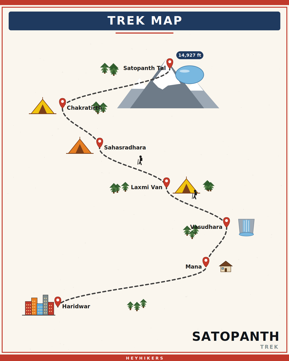
The trek begins at Mana (10,500 ft) with a gentle climb past Bhim Pul along the right bank of the Alaknanda. Day 3 covers the 11 km to Laxmi Van (12,300 ft) via the spectacular 400-foot Vasudhara Falls, climbing through scrubby juniper and stunted birch. Day 4 climbs the moraine ridge through the multi-channelled Sahasradhara springs to Chakratirth (13,800 ft), named for Vishnu's Sudarshan Chakra. Day 5 is summit day — a pre-dawn climb across snow patches and a final ridge to Satopanth Tal at 14,927 ft. The lake itself is small (about 250 metres across), unbelievably clear, and ringed by ice walls; pilgrims since the 13th century have circumambulated its perimeter leaving offerings of marigold, tulsi, and rice.
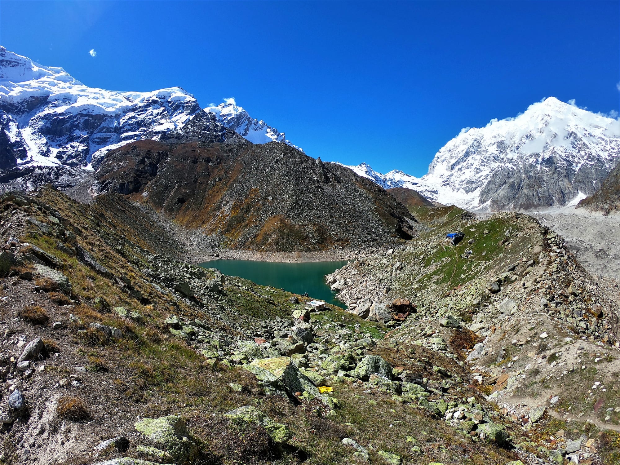
What you'll see at the lake
The basin around Satopanth is a natural amphitheatre. Looking south you see the colossal pyramid of Neelkanth (21,640 ft) — sometimes called the 'Queen of Garhwal' — and behind it the western ridges of the Chaukhamba massif (23,419 ft, the source of the Alaknanda). To the east, Balakun (20,571 ft) cuts a sharp profile. The lake itself is bordered by glacial moraine and is fed by snow melt; in mid-summer the eastern shore is grassy and ice-free, while the western shore retains snow into August. The water is unbelievably clear — you can see the rocky lakebed five metres down — and a faint pink algal bloom is visible on cold mornings.
Difficulty and prerequisites
Satopanth is a graded moderate-to-difficult trek. The altitude (14,927 ft summit, 13,800 ft highest sleep) places it firmly in AMS-risk territory and we require trekkers to be cardiovascularly fit (5 km in 35 minutes), with at least one prior trek above 12,000 ft. The summit day is 14 km of round-trip walking with 1,100 ft of gain at very thin air; we leave Chakratirth at 5 AM with headlamps and aim to be back by 2 PM. There is no technical climbing but there are exposed sections and snow patches that warrant microspikes from October onwards.
Best season and weather
The trek runs reliably from late May to late June and again from mid-September to mid-October. July and August are monsoon and the trail becomes treacherous with rain and rockfall above Laxmi Van. November onwards the lake freezes and the trail is buried under snow. The best window for photography is the second half of September — clear post-monsoon skies, golden grass, and the high peaks freshly dusted with the season's first snow.
Camping and infrastructure
The first night is in a Joshimath guesthouse (hot water, beds). Mana has a few basic homestays. From Day 3 onwards we camp in tents — Laxmi Van has a few stone shelters used by sadhus, and Chakratirth is a designated forest department campsite. We provide two-person tents, sleeping bags rated to -10°C, and a kitchen tent. There is no mobile network past Mana; we carry satellite communicators. Pit toilets at every camp.
Cultural and historical context
This is one of the few high-altitude treks in India where the pilgrim tradition has remained completely uninterrupted. You will share the trail with sadhus walking barefoot, with elderly Hindu pilgrims carrying simple bedrolls, and with Bhotiya traders who still graze livestock on the upper meadows. Mana itself has the famously inscribed 'Bharat ki Aakhri Chai ki Dukaan' (the last tea shop in India), a legitimate cultural institution. The trek is best treated as a hybrid expedition-pilgrimage — respect for the route's spiritual significance is part of the contract.
Itinerary
Map
What trekkers say
"I'd never camped in snow before. The HeyHikers team made me feel safe every single step. The summit sunrise — standing at 12,500 ft watching peaks turn gold — I cried. Not from the cold. From the beauty."
PS
Priya Sharma
Kedarkantha, Dec 2025
"Seven lakes, each more unreal than the last. The logistics were flawless — the food at 13,000 ft was better than most restaurants I know. Our guide Farooq knew every stone on the trail. Doing Goechala with them next."
AM
Arjun Mehta
Kashmir Great Lakes, Aug 2025
Inclusion
- All meals during the trek (vegetarian, freshly cooked)
- Camping gear — tents, sleeping bags, mats
- Certified trek leader and support guides
- Forest department permits and entry fees
- First-aid kit and supplemental oxygen
- Basecamp accommodation on twin/triple sharing
Exclusion
- Travel to and from the basecamp pickup point
- Personal trekking gear and clothing
- Travel insurance covering high-altitude trekking
- Tips, personal expenses, and meals during travel days
- Anything not explicitly listed under inclusions
Things to Carry
- Trekking shoes (high-ankle, broken-in)
- 40-50L backpack with rain cover
- Two pairs of trek pants
- Three full-sleeve t-shirts (synthetic, not cotton)
- Fleece jacket and a heavier down/insulated jacket
- Thermal innerwear (top + bottom)
- Waterproof outer shell (jacket + pants)
- Woollen cap, sun cap, balaclava
- Two pairs of warm gloves (inner liner + outer)
- UV-rated sunglasses
- Headlamp with spare batteries
- Reusable water bottles (2L total) or hydration bladder
- Personal medical kit and prescription medicines
- Sunscreen (SPF 50+) and lip balm
- Toiletries and quick-dry towel
- Original photo ID (mandatory at forest checkposts)
How to Reach
Reach Haridwar. Our shared transport leaves at 6:00 AM on Day 1 and reaches Joshimath in 10-12 hours. Day 2 drives you to Mana village beyond Badrinath where the trek begins.
Safety & Security
- Acclimatize properly — never skip rest days at altitude.
- Drink at least 4 litres of water per day above 9,000 ft.
- Tell your trek leader immediately if you feel headache, nausea, or breathlessness — early AMS signs are treatable, ignored ones are not.
- Stay close to the group; do not take shortcuts off the marked trail.
- Avoid alcohol and smoking for the entire duration of the trek.
- Keep a buffer day for travel — Himalayan roads can close without notice.
- Carry travel insurance that explicitly covers high-altitude trekking and helicopter evacuation.
Cancellation Policy
Cancellations must be requested in writing.
- More than 30 days before the trek start date: 90% refund. - 21–30 days before: 50% refund. - 11–20 days before: 25% refund. - 10 days or fewer: no refund, but you may transfer your slot to another trekker or to any future batch within 12 months at no extra charge.
Refunds are processed to the original payment method within 7-10 working days. Trip cancellations triggered by us (weather, force majeure, government restrictions) are refunded in full or moved to an alternate batch at your option.
Meet your trek leader
Akhil Deruwan
NIM Uttarkashi certified · 9 yrs experience
Akhil grew up in the foothills of the Garhwal Himalayas and has spent nearly a decade navigating its most demanding trails. He has led over 150 batches across Uttarakhand and Himachal Pradesh, with a strong focus on technical high-altitude routes and safety management. His calm under pressure and deep knowledge of local terrain make him a trusted leader for both beginner and advanced trekkers.
- Wilderness First Responder
- High Altitude Medicine
- Technical Route Navigation
- Search & Rescue
FAQ
Why Trek With Us
Travel Safe
Certified Team
Easy Cancellation
Well Equipped Campsite
Experienced Guide
No Hidden Charges